


Rivers and Seas Watch
Rivers and Seas Watch helps you stay informed about storm overflow releases across our region. Here you can access our interactive map and find useful resources including FAQs and information about tidal modelling.

Overview
Rivers and Seas Watch is our online service which provides near real-time information about storm overflow releases across our region. When a potential storm overflow release is identified by our monitoring equipment (EDMs), a release event is created and shown on Rivers and Seas Watch. Every storm overflow outfall in our region is shown.

How to use Rivers and Seas Watch
Rivers and Seas Watch has three main features:
-
The interactive map
-
Release history
-
Useful information and FAQs
You can also sign up for email updates to keep updated about specific bathing sites and receive alerts when there has been a storm overflow release that may have impacted bathing water quality.
We'd love to hear your feedback, let us know what you think of the service and its data.
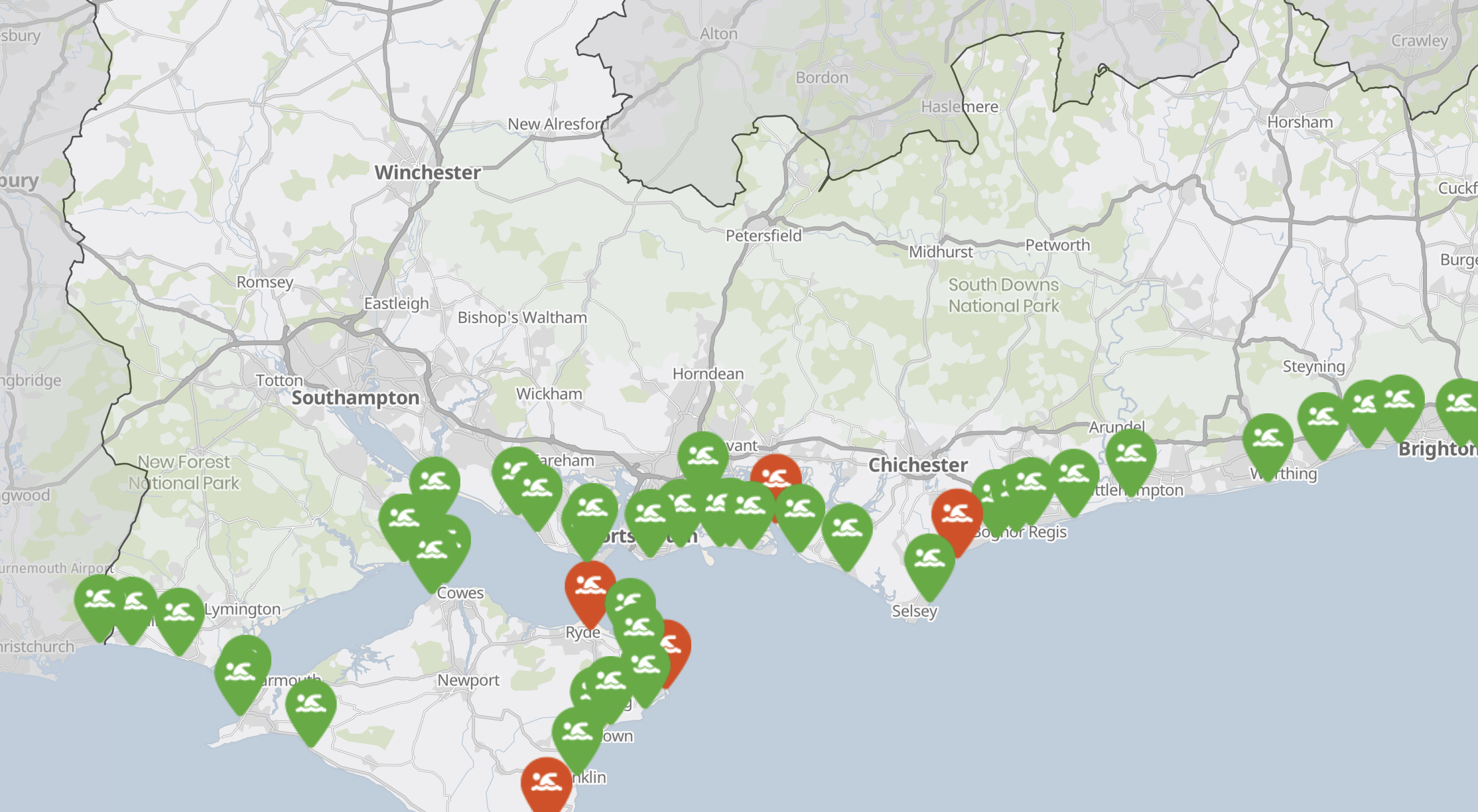
Interactive map
To use the map, simply locate the area or bathing water you’re interested in. You can do this by zooming in or using the search bar.
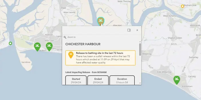
 Select a bathing water pin to see details of any recent releases associated with that bathing water, the outfall(s) associated with the bathing water, and navigation to the release history. Some outfalls are associated with more than one bathing water.
 Select an outfall circle to see details of any recent releases, the bathing water(s) it is associated with, and navigation to the release history.
 Shaded areas show the bathing water areas we base our tidal modelling on to determine if a storm overflow will impact water quality.
Icons and legend
Outfall circles changes colour depending on how recently there has been a storm overflow release.
Bathing water pins and areas change colour depending on how recently there has been a release from any associated outfalls that could impact bathing water quality.
 Red: Release(s) in the last 24 hours
 Amber: Release(s) in the last 72 hours
 Green: No releases in the last 72 hours

Release history
Our Rivers and Seas Watch release history allows you to filter by date, bathing water, outfall, status and impact. You can also customise the table columns.
We also included the option to download results from the table, using the ‘actions’ button.
To see our annual storm release data, you can visit our flow and spill reporting pages.
How do I know when there's been a storm overflow release?
We have an extensive review process to make sure the storm overflow release data we provide is as accurate as possible.
Watch the video to find out more about this process.
How do you know if a storm overflow release has impacted bathing water?
Bathing water areas
The coloured beachfront areas shown on Rivers and Seas Watch represent bathing water areas that are frequently used by the public, and are part of the Environment Agency’s water quality sampling regime.
The pin inside the coloured area shows the sampling point where the EA take their water quality samples to determine bathing water classifications.
Because of the frequent use of these bathing waters by the public, we’ve created tidal models for the areas shown.

Tidal modelling
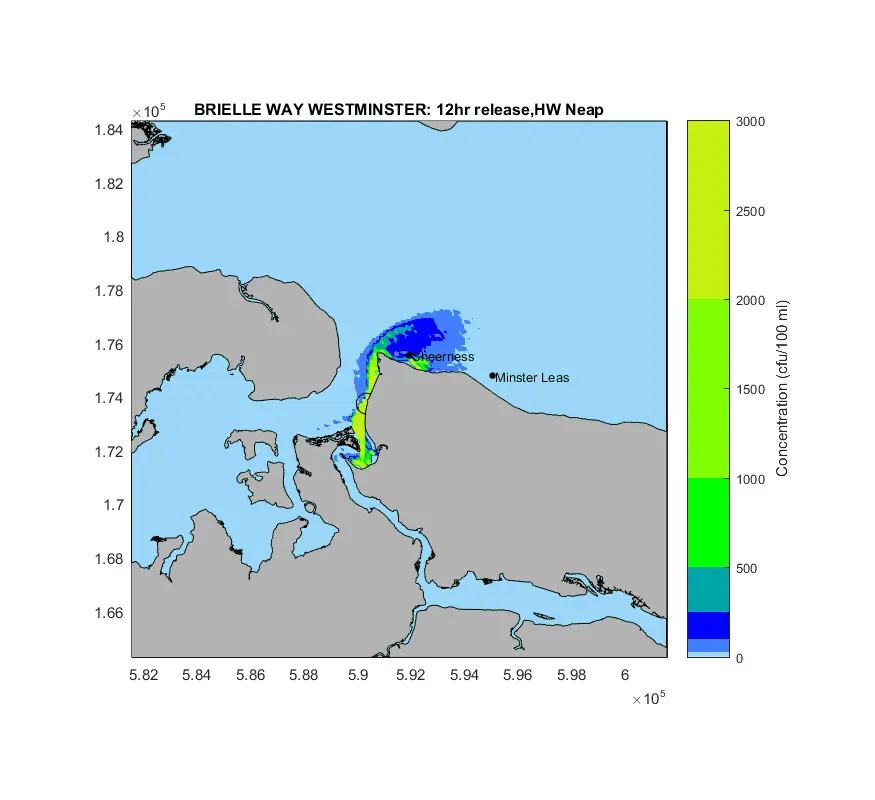
One of the key components of ensuring we provide the most accurate storm overflow data possible is our tidal modelling.
Tidal modelling means creating scenarios, called models, and testing mock storm overflows in them to see how they behave in each different condition.
When a real storm overflow alert comes in, our automated systems use the models to predict how the real release will behave so we can notify our customers immediately if the release is likely to have impacted bathing water quality.

The science
Our tidal models have been created using several data sets including the location of the outfall, the duration of the release, tidal and weather conditions and the position of the moon and the sun. All this can change how the release behaves once it enters the water.
We have 5000 different models that our automated systems cross-reference, finding the closest match to the real-life release. These have been robustly checked against survey data such as tidal levels, current speed and direction, and dye tracing, ensuring that the model is performing as close to a real storm overflow release as possible.
Latest updates and features
The latest new update to Rivers and Seas Watch was February 5 2026.
Key changes
-
A fresh look and changes to make it easier to explore the map and view data clearly
-
Bathing water panels now show any impacting releases from the last 72 hours
-
Clearer display of bathing water and outfall information using a dedicated side panel and tabbed sections
-
Updates to the release history table, including export control, clearer file names, and confirmation of completed downloads
-
You can now zoom to your current location using location services
-
Improvement work on 29 overflows that were originally scheduled for 2028 will now begin this year, the Investment plan map has been updated to reflect this
Read the full release notes and download other release notes below.

Beachbuoy Independent Review
We asked a group of independent experts to conduct an assessment of our previous storm overflow monitoring service, Beachbuoy, and its ability to provide consistent, reliable and credible near real-time warnings of potential water quality impacts from storm overflow releases, and to provide a series of recommendations to improve the accuracy and user trustworthiness and confidence of the system.
We’re committed to acting on the recommendations and have incorporated them as both short and long-term goals for our new service, Rivers and Seas Watch, details on timeframes are outlined in report.
Before publication, time was given for the report to be reviewed by our stakeholder community – providing them with an opportunity to feedback and ask questions to the independent experts via individual sessions, email exchanges and our working group meeting. Minutes from the meeting can be found here: Beachbuoy WG January 31 2024 Minutes
We’re committed to acting on many of the recommendations as part of our new and improved service, Rivers and Seas Watch, complete with all inland outfalls and improved usability in features.
To request previous or unredacted versions of this report please email beachbuoy.independentreview@southernwater.co.uk